

Floor Area Ratio (FAR), height, setbacks, and lot coverage are four of the most important zoning controls shaping development potential. Each one answers a different question: FAR limits total floor area, lot coverage limits the ground-level footprint, setbacks define where the building may sit, and height controls how far the building can rise.
For developers, the important question is not:
“Which one matters most?”
It is:
“Which combination of these controls actually determines what can fit on this parcel?”
These controls work together. A site may have enough FAR on paper but insufficient height or footprint to use it. A large buildable footprint may still be constrained by FAR. Generous height may not help if setbacks or lot coverage make the floor plate too small.
This is why early feasibility should test all four on the actual parcel rather than reading them as separate zoning values.
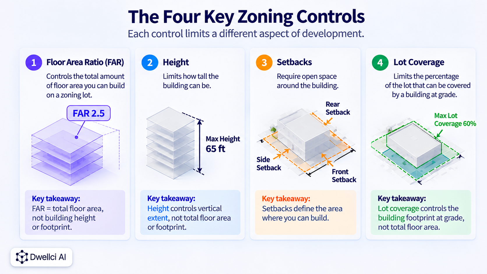
FAR controls the quantity of floor area relative to lot size.
The general relationship is:
FAR = total zoning floor area ÷ lot area
New York City's Zoning Resolution defines FAR as total floor area on a zoning lot divided by lot area. NYC's zoning definitions provide a formal example.
For a 10,000-square-foot lot with FAR 2.5:
10,000 SF × 2.5 = 25,000 SF of theoretical zoning floor area
FAR tells you how much floor area zoning may permit in total. It does not tell you the footprint, number of stories, or final building shape.
See Floor Area Ratio (FAR): What Developers Need to Know for a deeper explanation.
Lot coverage limits how much of the zoning lot may be covered by the building when viewed from above.
NYC's Zoning Resolution defines lot coverage separately from FAR and regulates the two with distinct limits in many zoning districts. The definitions and current FAR and lot-coverage tables illustrate this distinction.
The general calculation is:
Maximum footprint = lot area × maximum lot coverage
On a 10,000-square-foot lot with 60% maximum lot coverage:
10,000 SF × 60% = 6,000 SF maximum footprint
That 6,000 square feet is a footprint limit. It is not the same as total building floor area.
See FAR vs. Lot Coverage: What's the Difference? for the full comparison.
Setbacks and yards define required open distances along property lines or streets.
NYC's Zoning Resolution defines a yard as the portion of a zoning lot that remains open and unobstructed along a lot line for the depth or width required by the applicable district regulations. The zoning definitions distinguish front, side, and rear yards.
For a rectangular 100-foot by 100-foot lot, if zoning requires:
the setback-defined rectangle becomes:
80 ft × 70 ft = 5,600 SF
That means the setback geometry is more restrictive than the gross 10,000-square-foot lot area.
See How Setbacks Affect Development Yield for more examples.
Height rules limit how far a building may extend vertically.
Some zoning districts use a straightforward maximum building height. Others combine:
NYC's current residential zoning includes districts where a maximum base height applies and upper portions of the building must step back before reaching the maximum building height. Section 23-423 illustrates how setbacks can become part of the vertical envelope.
Height therefore determines not just how tall a building may be, but sometimes how the upper floors must be shaped.
The four controls answer four different parts of the same development problem:
A development scenario has to satisfy all of them simultaneously.
If the building cannot fit within the combined limits, theoretical zoning capacity may remain unused.
Consider a simplified site with:
10,000 SF × 2.5 FAR = 25,000 SF
So zoning may permit up to 25,000 square feet of floor area.
10,000 SF × 60% = 6,000 SF
The footprint may not exceed 6,000 square feet based on coverage alone.
The setbacks leave:
80 ft × 70 ft = 5,600 SF
In this example, the setback-defined area is tighter than the 6,000-SF lot-coverage limit.
If the 45-ft height limit supports roughly four full stories for the assumed building type, then:
4 × 5,600 SF = 22,400 SF
The modeled building would use approximately:
22,400 ÷ 10,000 = 2.24 FAR
Theoretical zoning capacity is 25,000 SF.
The simplified envelope supports approximately 22,400 SF before considering circulation, cores, parking, access, open space, upper-level step-backs, or other project requirements.
About 2,600 SF of theoretical FAR remains unused.
The controlling combination in this simplified example is the setback-defined footprint plus the height limit—not the FAR itself.

The binding constraint is the rule—or combination of rules—that actually limits the development scenario.
It can vary by site.
Identifying the binding constraint is more useful than simply listing every zoning standard.
Suppose a 10,000-square-foot lot permits FAR 4.0, or 40,000 square feet of theoretical floor area.
If setbacks and lot coverage allow a 6,000-square-foot footprint but the height limit effectively supports only four stories:
4 × 6,000 SF = 24,000 SF
The site may use only about 2.4 FAR even though 4.0 FAR is permitted.
In that case, height is effectively the controlling factor.
Now assume the same lot allows a 100-ft building but only FAR 2.0.
The maximum theoretical floor area is:
10,000 SF × 2.0 = 20,000 SF
The zoning envelope may be capable of holding much more than 20,000 square feet, but the project must stop when the permitted floor area is reached.
In that case, FAR is the binding control.
Assume a 10,000-square-foot lot allows 70% coverage, which would permit a 7,000-square-foot footprint.
If setbacks leave only 5,600 square feet, the setbacks control the footprint.
This is why a coverage percentage should never be interpreted without applying the actual parcel geometry and setback lines.
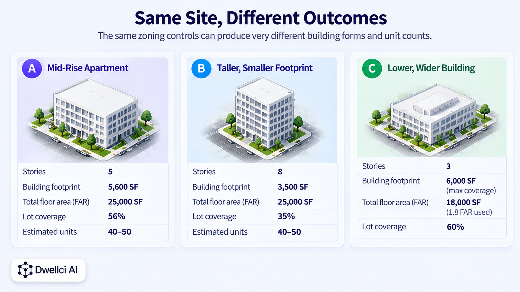
NYC's 2025 Zoning Handbook illustrates that the same FAR can be arranged as different building forms depending on lot coverage and other bulk controls. The handbook shows the same floor-area quantity distributed across wider, lower buildings and narrower, taller buildings.
This is why FAR alone does not tell you what the building will look like.
The massing depends on the other dimensional controls.
Together, these controls establish the basic regulatory geometry of the site.
Setbacks and coverage shape the lower footprint. Height and upper-level setbacks shape the vertical volume. FAR limits how much of that volume may actually be filled with zoning floor area.
The result is the buildable envelope.
A preliminary massing scenario then tests how a real development program might fit inside that envelope.
Even after these four zoning controls are applied, practical development capacity can be lower because of:
This is why a zoning envelope is not the same as a final building.
Mapped overlays and parcel-specific constraints can further modify the practical scenario; see Zoning Overlays & Site Constraints.
A practical screening sequence is:
This turns four abstract zoning controls into a development decision.
For a broader diligence workflow, see Zoning Due Diligence Checklist for Developers.
A decision-ready feasibility report should show more than the raw numbers.
It should make visible:
See What Should a Real Estate Feasibility Report Include? for the full reporting framework.
Dwellci AI is designed to evaluate FAR, height, setbacks, lot coverage, parcel geometry, and site constraints as an interacting system.
Rather than presenting zoning values in isolation, the platform uses those inputs to create zoning-backed 3D feasibility and development metrics so teams can see what appears physically achievable on the parcel.
The objective is to help developers move from:
“What are the zoning numbers?”
to:
“What do those zoning numbers actually produce on this site?”
There is no universal answer. The controlling factor depends on the parcel, zoning district, lot type, and development program. The binding constraint is whichever rule—or combination of rules—actually limits the feasible massing.
Not necessarily. Setbacks, lot coverage, parking, parcel geometry, access, environmental constraints, and building efficiency can still prevent the full FAR from being used.
Yes. Lot coverage is a percentage limit, while setbacks define where the building may sit. If setbacks leave a smaller area than the percentage-based coverage limit, the setbacks become more restrictive.
No. If FAR is already exhausted, additional height may create unused envelope volume. Height only creates more usable development capacity when other controls allow additional floor area to be added.
No. The terminology, formulas, exceptions, bonuses, exclusions, and dimensional standards vary by jurisdiction. The framework is broadly useful, but the applicable local zoning code must always be verified.