

Zoning overlays and site constraints can materially change development potential even when the base zoning district looks attractive. An overlay or special district adds another regulatory layer on top of the base zoning, while a site constraint is a physical, environmental, legal, or infrastructure condition that can reduce the practical area available for development or increase cost, approvals, and risk.
For developers, the key question is not simply:
“What is the base zoning?”
It is:
“What additional regulatory layers and parcel-specific constraints change what this site can actually support?”
The simplest distinction is:
They can interact, but they are not the same thing.
New York City's Zoning Resolution provides a clear example of an overlay-style regulatory structure: Special Purpose Districts are mapped over other zoning districts and their regulations supplement or modify the rules of the underlying districts. NYC ZR Section 11-123 states this explicitly.
By contrast, a utility easement, steep slope, flood-hazard area, or environmental condition may affect the development scenario without changing the base zoning designation itself.
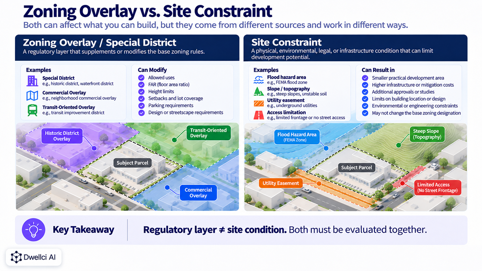
A zoning overlay is an additional mapped or regulatory layer applied to a property in addition to its base zoning district.
The terminology varies by jurisdiction. Cities may use terms such as:
The important concept is that the base district may not contain the complete rule set.
In NYC, Articles VIII through XIV of the Zoning Resolution contain Special Purpose District regulations, and those special districts can modify otherwise applicable use, bulk, parking, streetscape, or other requirements. NYC's current Zoning Resolution shows the base-district and special-district structure.
Some overlay systems allow an additional use layer within another base zoning context.
NYC's zoning definitions, for example, recognize C1 and C2 commercial districts mapped within residence districts as commercial overlays subject to Article III commercial regulations. NYC's zoning definitions provide one example of how a mapped overlay can change the use framework without replacing the underlying residential district altogether.
For a development team, this means a parcel cannot always be analyzed correctly from the base district label alone.
An overlay or special-purpose district can affect much more than whether a use is permitted.
Depending on the jurisdiction, it may modify:
This is why a development feasibility analysis should identify every mapped regulatory layer before calculating yield.
A site constraint is a condition that can affect how much of the parcel is practically usable, how the building must be configured, or how much diligence and approval work may be required.
Common site constraints include:
Some of these constraints are regulatory. Some are physical. Some are legal. Some create cost rather than reducing the zoning envelope directly.
The development impact depends on the specific site and project.
Flood mapping is a good example of why developers should keep regulatory layers and site constraints conceptually separate.
FEMA's Flood Map Service Center is the official public source for flood-hazard information produced for the National Flood Insurance Program. FEMA's Flood Map Service Center can be used to identify mapped flood-hazard conditions.
A flood zone may trigger building, insurance, elevation, floodplain-management, or local development requirements, but it should not automatically be described as part of the property's base zoning.
Some jurisdictions may incorporate flood or coastal risk into zoning overlays or special districts, while others regulate it through separate floodplain or building-code frameworks.
The correct analysis therefore asks both:
Wetlands and waters are another important example of a constraint that may require separate regulatory review.
Under Section 404 of the Clean Water Act, discharges of dredged or fill material into waters of the United States, including regulated wetlands, generally require authorization unless an exemption applies. EPA's Section 404 permit-program guidance explains the federal framework.
For a developer, the important early question is not simply whether a wetlands layer appears on a map.
It is whether the condition changes:
Those questions may require environmental or jurisdictional confirmation beyond phase-zero screening.
An easement may reserve a portion of the property for utilities, access, drainage, or another legal right.
The base zoning can remain unchanged while the easement limits where a building, foundation, parking area, or other improvement can be placed.
That means a site may appear to have a large zoning envelope until the title and survey conditions are layered onto the parcel.
For acquisition diligence, easements should be treated as a separate legal/site layer rather than assumed to be reflected in the zoning data.
Slope and topography do not always reduce the zoning capacity numerically, but they can materially affect practical feasibility.
Steep or irregular terrain may change:
A site with strong zoning but difficult topography can therefore be less attractive than a flatter site with slightly lower theoretical density.
A parcel can be physically capable of supporting the intended building and still carry environmental risk.
Contamination, underground storage tanks, prior industrial uses, or other environmental conditions may require investigation, remediation, or additional transaction diligence.
These issues should be distinguished from zoning so a developer does not interpret a “zoning-feasible” site as fully de-risked.
For a broader acquisition framework, see Zoning Due Diligence Checklist for Developers.
The most important feasibility problems often occur when multiple layers overlap.
Consider a parcel with:
Each layer may be manageable by itself.
Together, they can substantially change the development scenario.
The special district may reduce or reshape the zoning envelope. The easement may remove part of the remaining footprint. Flood-related requirements may change ground-floor design or cost. The commercial overlay may create an opportunity for mixed-use frontage.
The correct result comes from layering them together—not reviewing each in isolation.
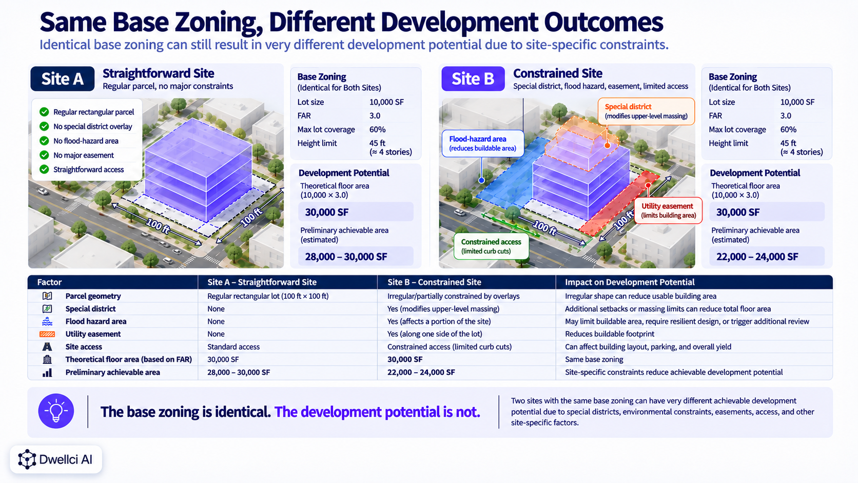
Imagine two 10,000-square-foot parcels with the same base zoning, FAR 3.0, 60% lot coverage, and the same nominal height limit.
Theoretical zoning capacity for each is:
10,000 SF × 3.0 = 30,000 SF
A preliminary massing may be able to capture most of the theoretical 30,000 square feet.
Site B may still be developable, but the achievable floor area, cost, design, schedule, and diligence path can look materially different.
The base zoning is identical. The development potential is not.
When combining multiple data layers, avoid counting one condition twice.
For example:
The feasibility model should distinguish the source and effect of each constraint so the same rule is not applied multiple times.
Maps are useful for screening, but not every displayed layer has the same legal status.
A map may represent:
That distinction matters.
Material conclusions should be traced to the authoritative zoning text, official map, agency record, survey, title document, environmental determination, or other appropriate source.
A practical workflow is:
This converts a stack of map layers into a decision-ready development scenario.
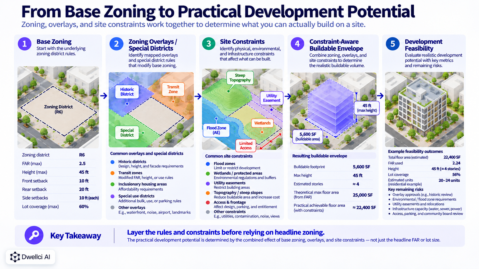
The zoning-defined buildable envelope is only the starting regulatory volume.
A practical development envelope may be smaller after parcel-specific constraints are applied.
For example:
The final massing should reflect those combined effects rather than displaying the full zoning envelope as though it were automatically usable.
An overlay or special district does not automatically make a site worse.
It can create:
But it can also introduce:
The acquisition question is whether the overlay creates more value than complexity for the intended program.
A site constraint should be translated into its development consequence.
Instead of simply labeling a site “flooded,” “sloped,” or “easement-affected,” estimate how the condition changes:
This makes the constraint useful in acquisition underwriting rather than leaving it as an abstract warning.
For an apples-to-apples comparison method, see How to Compare Development Sites Before Acquisition.
A decision-ready feasibility report should clearly separate:
Useful visuals include:
See What Should a Real Estate Feasibility Report Include? for the broader reporting framework.
Dwellci AI is designed to help development teams evaluate zoning and site conditions as interacting layers rather than disconnected data points.
The platform combines parcel intelligence, zoning analysis, site constraints, and zoning-backed 3D feasibility so teams can understand how regulatory overlays and parcel-specific conditions change the practical development scenario.
The objective is to help developers identify both opportunity and risk earlier—before significant capital is committed.
Not necessarily. A base zoning district establishes the primary zoning framework. An overlay or special district is an additional layer that may supplement or modify the base regulations. Terminology varies by jurisdiction.
Not automatically. FEMA flood mapping is a separate federal hazard dataset. Some local jurisdictions incorporate flood or coastal-risk conditions into zoning overlays or special districts, while others regulate them through separate floodplain, building-code, or development rules.
Not necessarily. An easement may leave the permitted FAR unchanged while reducing the practical area available for a building, access, parking, or foundations. That can make some theoretical FAR difficult to use.
Yes. Depending on the jurisdiction, an overlay or special district may permit additional uses, density, bonuses, or other development opportunities. It may also add requirements or approvals, so the net effect must be evaluated for the specific project.
They should be screened during initial site evaluation and analyzed more carefully before acquisition assumptions are treated as reliable. Material issues should be verified during formal due diligence.