

A zoning lookup tells you the regulatory starting point for a property—typically its zoning district and related mapped designations. A development feasibility analysis goes further: it applies zoning, parcel geometry, dimensional controls, site constraints, access, and development assumptions together to estimate what may actually be buildable on that specific site.
For an acquisition team, that difference matters because the question is rarely just “What is the zoning?”
The more useful question is:
“What does the zoning mean for this property and this development program?”
A zoning lookup is primarily an information-retrieval step. It helps identify the zoning district, mapped overlays or special districts, and the regulatory sources that may apply to a parcel.
A development feasibility analysis is a site-specific decision-support process. It takes the relevant rules and applies them to the actual property, along with physical and development assumptions, to estimate a plausible development outcome.
These steps are related, but they are not interchangeable.
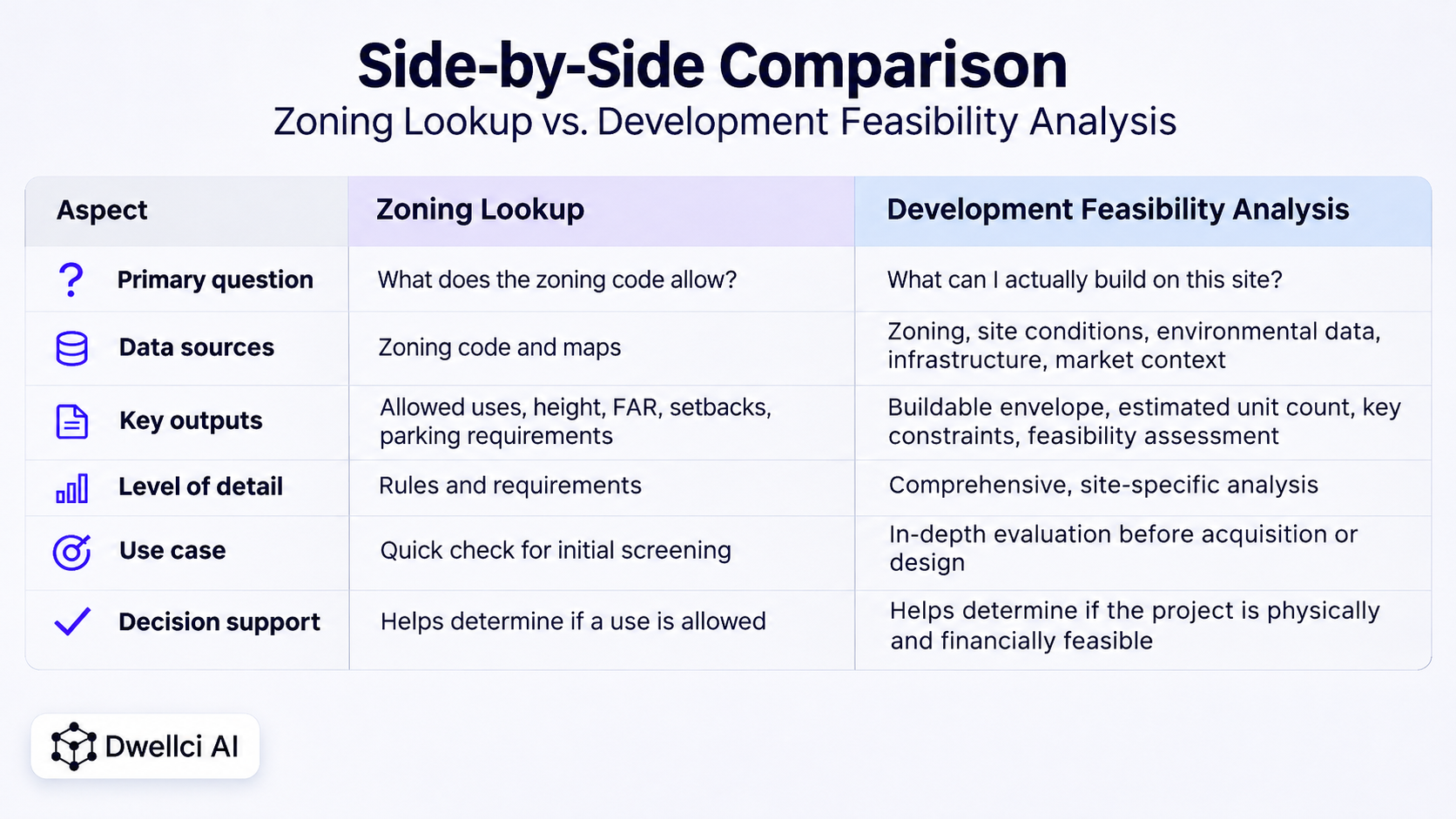
A zoning lookup usually begins with an address, parcel number, or map location.
Official zoning tools can help identify the zoning district associated with a property and, depending on the jurisdiction, may also show commercial overlays, special districts, historic zoning maps, or other mapped information.
New York City's Department of City Planning, for example, directs property owners to ZoLa to identify a property's zoning designation and related zoning information. The City's Zoning Resolution separately contains the maps and regulatory text governing land use and development. NYC's zoning FAQ and Zoning Resolution illustrate this distinction between identifying the district and interpreting the rules.
Depending on the local system, a zoning lookup may help you identify:
That information is valuable. But it is still the beginning of the analysis.
A zoning district is not the same thing as a buildable development scenario.
Knowing the district does not automatically tell you how much of the permitted floor area can physically fit, whether setbacks create an inefficient footprint, how lot geometry affects massing, whether parking or access requirements consume usable area, or whether mapped site conditions create additional constraints.
Even the zoning rules themselves may require multiple provisions to be read together. New York City's Zoning Resolution, for example, contains separate regulations governing use, bulk, parking, and special-purpose districts rather than reducing every property to a single zoning number. The Zoning Resolution overview explains how those articles and maps work together.
A zoning lookup therefore answers an important question:
What regulatory framework should I investigate?
It does not necessarily answer:
What can I realistically build?
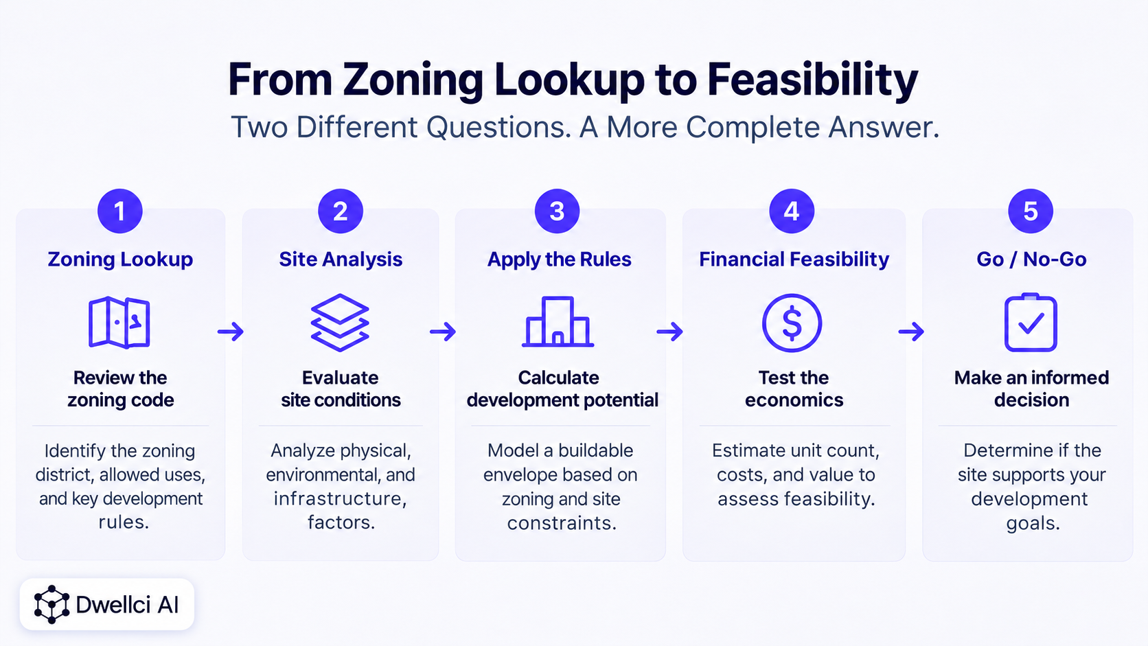
A development feasibility analysis translates regulatory and property information into a plausible site-specific outcome.
For early acquisition screening, that typically means combining several layers of information:
That combination is what turns zoning information into a site feasibility analysis.
EPA's site-feasibility guidance, although written for contaminated or formerly contaminated sites considered for renewable-energy reuse, illustrates the broader principle clearly: contamination, topography, regulated flood zones, and parcel dimensions can all affect developable area and project viability. EPA's Site Conditions and Feasibility guidance shows why zoning alone is not the full site-development picture.
Imagine two neighboring parcels with the same zoning district and the same permitted FAR.
A zoning lookup may make them appear similar.
But Parcel A is rectangular, has strong frontage, straightforward access, and no major mapped constraints.
Parcel B is narrow, irregular, partly within a flood-hazard area, and affected by a utility easement.
The zoning designation may be identical.
The development outcome may not be.
Parcel B may have less usable footprint, a less efficient massing configuration, more site-work uncertainty, or a different entitlement and diligence path.
This is why a developer comparing acquisition opportunities should move from district identification to parcel-specific feasibility before treating theoretical zoning capacity as practical development capacity.
Development regulations interact.
A parcel may have enough theoretical FAR for a proposed program but lack enough footprint to use it efficiently. A height limit may prevent unused floor area from being stacked vertically. A setback may reduce the building width. Parking or access requirements may compete with the building footprint.
The relevant question is therefore not just whether each individual rule is satisfied in isolation.
It is whether the rules can work together on the specific parcel.
For a deeper explanation of those controls, see What Can I Build on This Property? 7 Factors That Determine Development Potential.
Zoning is only one layer of feasibility.
Flood conditions, wetlands, topography, environmental conditions, easements, existing improvements, infrastructure, and access can all affect the portion of a property that is practically usable for development.
FEMA's Flood Map Service Center is the official public source for flood-hazard information produced for the National Flood Insurance Program, making flood screening one example of a site-specific layer that may need to be considered alongside zoning. FEMA's Flood Map Service Center provides the official mapping resource.
A preliminary feasibility analysis should not pretend these issues have been fully resolved. It should identify them early enough that the acquisition team knows which assumptions need deeper professional verification.
Another important distinction is between site feasibility and financial feasibility.
A site may be physically and regulatorily capable of supporting a project but still fail economically.
Conversely, an attractive market opportunity does not make a physically constrained site buildable.
Public-sector development-feasibility work often treats land use, infrastructure, market conditions, and financial viability as separate but connected analyses. San Diego County's Development Feasibility Analysis, for example, evaluates zoning, infrastructure, market feasibility, and financial feasibility as distinct components of the broader development question. San Diego County's DFA overview provides a useful example.
For acquisition screening, a sensible sequence is:
A zoning lookup can be enough when the objective is simply to identify the district, confirm a mapped designation, or determine which zoning provisions should be reviewed next.
It can also be useful during very early market scanning when you are narrowing a large universe of properties.
But once the question becomes acquisition-specific—particularly when comparing sites, estimating development yield, negotiating land value, or deciding whether to spend money on professional diligence—a zoning lookup alone is usually too shallow.
Move beyond a zoning lookup when you need to answer questions such as:
Those are feasibility questions, not lookup questions.
For a complete acquisition-screening process, see How to Evaluate a Development Site Before Acquisition.
An early-stage feasibility output should make the development assumptions visible rather than hiding them behind a single “buildable” number.
Useful outputs may include:
The Housing Toolbox's predevelopment guidance similarly separates zoning review from broader preliminary site assessment, engineering, conceptual design, and financial feasibility work. Its site assessment and financial feasibility guide is a useful example of why development decisions require more than a zoning designation.
Dwellci AI is designed for the phase-zero stage of real estate development, when teams need to understand a site's potential before committing significant capital or detailed design effort.
The platform combines parcel intelligence, zoning analysis, site constraints, and zoning-backed 3D feasibility so developers can move from “What is the zoning?” toward “What may this site actually support?”
The goal is not to replace architects, engineers, attorneys, surveyors, environmental professionals, or jurisdiction-specific review.
It is to help development teams screen opportunities earlier, identify the assumptions that matter, and focus deeper diligence on the sites that justify it.
For a comparison of traditional workflows with software-assisted screening, see Manual Site Feasibility vs. Feasibility Software.
No. A zoning lookup typically identifies the zoning designation and related mapped information. A zoning analysis goes further by interpreting the regulations that appear to apply to the property and proposed use.
No. Zoning analysis is one input to feasibility. A site-feasibility analysis also considers parcel geometry, dimensional controls, physical constraints, access, infrastructure, and a development scenario to estimate what may actually fit.
Not reliably by itself. Unit yield may depend on FAR or density rules, height, setbacks, lot coverage, parking, open space, parcel geometry, building efficiency, and other jurisdiction-specific requirements.
No. Early feasibility is decision support. Project-specific interpretations, permits, entitlements, environmental review, engineering, title, survey, and other professional or jurisdictional requirements may still need to be confirmed.
Ideally during initial site screening and acquisition due diligence, before significant capital is committed or detailed design begins.