
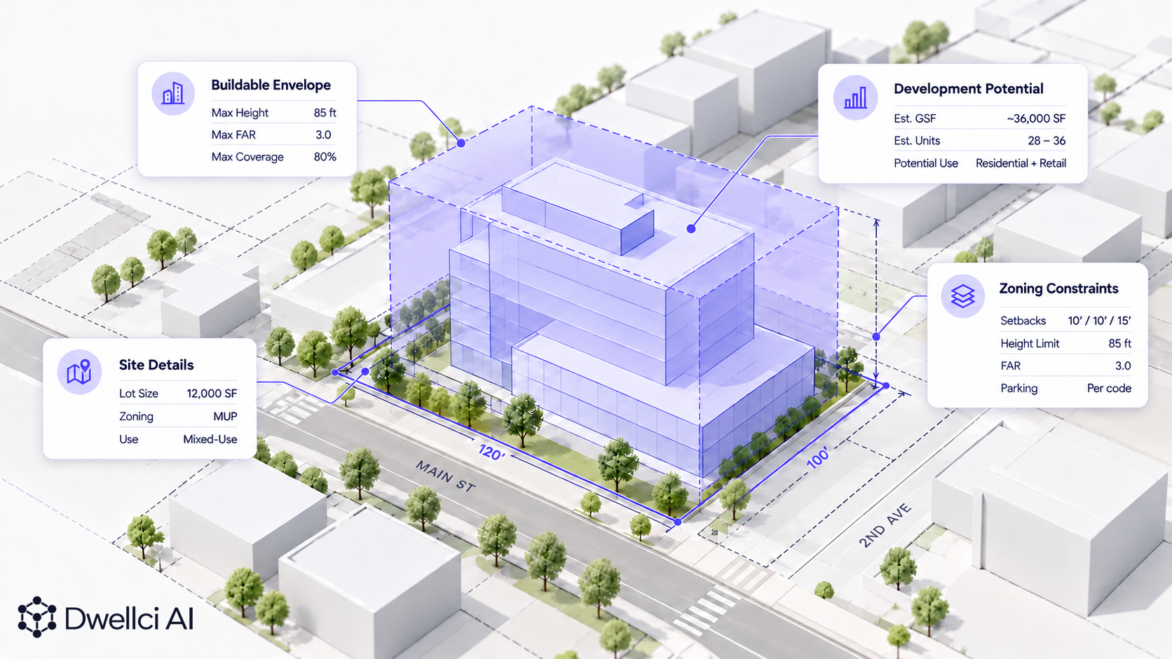
For developers, this is one of the most important questions to answer before design begins:
What can I physically and legally build here?
A parcel may look attractive based on its location, size, asking price, or zoning designation. But none of those factors alone tell you what the site can realistically support.
That requires feasibility analysis.
Site feasibility sits between finding a property and beginning detailed design.
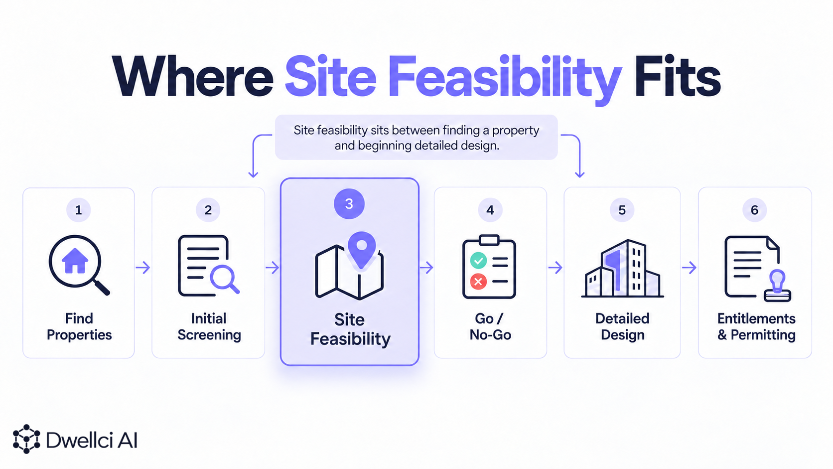
Its purpose is not to fully engineer or entitle a project. Instead, it helps a development team understand whether a site appears capable of supporting the intended development and what assumptions or constraints need further investigation.
A preliminary site assessment commonly considers the property itself, local and state regulations, conceptual development potential, infrastructure, and other physical constraints before more expensive predevelopment work begins. Housing Toolbox provides a useful overview of this early assessment process.
For an acquisition team, the result should help answer questions such as:
That is why site feasibility is best thought of as an early decision-making layer, not simply a zoning lookup.
Many development decisions are made when information is still fragmented. A team may know the parcel size. Someone may have identified the zoning district. A broker may provide an estimated buildable square footage. An architect may have an initial concept. But those pieces may not yet have been evaluated together.
The earlier conflicting assumptions are identified, the less time and money gets spent pursuing a development concept that does not fit the site.
This is particularly important during site acquisition and early due diligence, when developers often need to compare multiple opportunities quickly.
Feasibility therefore helps answer an early go, investigate further, redesign, or pass question before schematic design and more specialized professional work begin.
A useful feasibility analysis starts with the parcel and progressively applies the rules and constraints that affect development potential.

The first layer is the physical property itself: parcel boundaries, lot dimensions, area, existing improvements, access, and other site characteristics.
These facts create the base geometry against which development rules can be tested.
Two parcels with the same acreage may have very different development potential because of their shape, frontage, dimensions, existing conditions, or constraints.
Next comes the regulatory framework.
Depending on the jurisdiction, that may include permitted uses, density, Floor Area Ratio, maximum height, setbacks, yards, lot coverage, parking requirements, open-space requirements, overlays, special districts, and other dimensional standards.
The exact terminology and rules vary by jurisdiction.
For example, New York City formally defines Floor Area Ratio, or FAR, as total floor area divided by zoning-lot area. New York City's Zoning Resolution provides the formal definition.
Consider a simplified example.
Suppose a property contains 20,000 square feet of lot area and the applicable zoning permits an FAR of 2.5.
The basic FAR calculation would suggest:
20,000 SF × 2.5 FAR = 50,000 SF of theoretical floor area
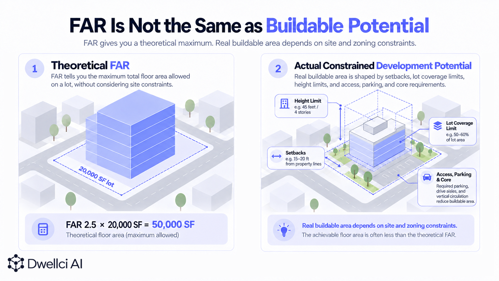
But that does not automatically mean a 50,000-square-foot building can be placed on the site in any configuration.
The project may still need to satisfy setbacks, height limits, lot coverage, yards, parking, open-space rules, or other controls. Site geometry can further constrain the possible building envelope.
So a useful feasibility analysis moves beyond the question:
“What FAR is allowed?”
and toward:
“How do all of the applicable rules work together on this specific parcel?”
That distinction is central to understanding development potential.
The buildable envelope is the three-dimensional space within which development may potentially occur after applicable dimensional constraints are considered.
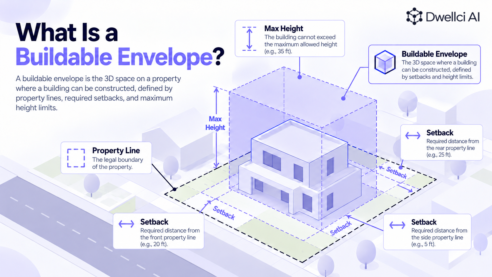
Setbacks can reduce the usable footprint. Height limits can constrain vertical development. Lot-coverage rules can limit how much of the parcel may be occupied. FAR can limit total floor area. Other zoning or site-specific conditions can reshape the envelope further.
This is why visualizing development potential in three dimensions can reveal issues that are difficult to understand from a table of zoning values alone.
The objective is not simply to collect regulations. It is to understand how those regulations affect the physical site.
Zoning is only one part of site feasibility.
Flood exposure, wetlands, topography, access, utilities, easements, environmental conditions, and other site characteristics may materially affect development.
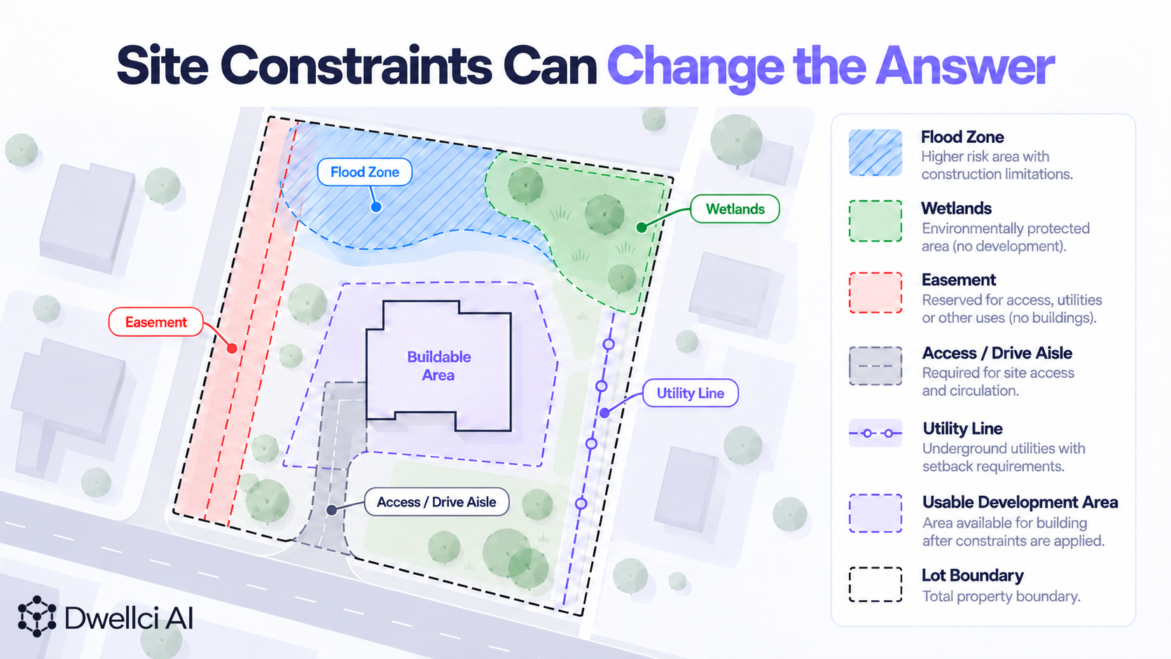
FEMA maintains official flood-hazard information through its Flood Map Service Center, and development within designated Special Flood Hazard Areas may be subject to additional community floodplain-management requirements. FEMA explains these requirements here.
Wetlands can also require additional investigation. EPA notes that certain activities involving dredged or fill material in waters of the United States, including regulated wetlands, may require authorization under Section 404 of the Clean Water Act. EPA provides additional guidance on wetlands and Section 404.
These conditions do not necessarily mean a property cannot be developed. They mean they should be identified early enough to influence the development strategy.
A zoning lookup answers:
What rules appear to apply to this property?
A feasibility analysis asks:
What do those rules mean for this particular site and development scenario?
That is a significant difference.
Knowing that a parcel has a certain zoning classification, FAR, height limit, or setback does not by itself produce a development concept.
Feasibility requires bringing those inputs together and translating them into buildable potential, development metrics, constraints, and scenarios that can support an actual acquisition decision.
Early feasibility should also not be confused with complete professional due diligence.
A phase-zero feasibility analysis is designed to identify opportunities, assumptions, and potential constraints early.
As a project advances, developers may still require land-use counsel, architects, engineers, surveyors, environmental professionals, title review, utility investigations, geotechnical work, entitlement analysis, and other project-specific services.
Environmental due diligence is a good example. EPA's All Appropriate Inquiries framework describes a formal process for evaluating environmental conditions and potential contamination liability before certain property acquisitions, typically involving qualified environmental professionals. EPA explains All Appropriate Inquiries here.
A preliminary feasibility platform should help teams understand where deeper investigation may be warranted, not replace specialized professional analysis.
The highest-value time is generally before substantial capital or design effort has been committed.
That can mean during initial site screening, while comparing acquisition opportunities, before or during an acquisition due-diligence period, or before launching schematic design.
At this stage, the objective is speed and clarity.
A developer may have ten potential properties but only enough time and resources to investigate two seriously.
The first feasibility pass helps determine which two deserve that investment.
A useful output should translate raw property and regulatory information into development intelligence.
That can include the applicable zoning and parcel conditions, a buildable envelope, zoning-backed 3D massing, development metrics such as FAR, height and site coverage, potential unit yield where appropriate, and clearly identified assumptions or constraints.

The goal is not to pretend uncertainty has disappeared.
It is to make uncertainty visible and actionable.
A developer should be able to look at the result and understand both the apparent opportunity and what still needs to be verified.
Dwellci AI is designed for this phase-zero stage of real estate development.
The platform helps developers screen properties, analyze zoning and site constraints, compare opportunities, and generate zoning-backed 3D feasibility with development metrics before significant capital is committed or detailed design begins.
Dwellci supports site analysis nationwide across all 50 U.S. states.
The objective is straightforward:
help development teams understand what a site may support earlier, so they can spend deeper due-diligence and design resources on the opportunities that justify them.
You can also learn more about Dwellci and the team behind the platform.
A site feasibility study evaluates whether a property appears capable of supporting a proposed development. Early-stage analysis typically considers zoning, parcel characteristics, dimensional controls, site constraints, and development assumptions before detailed design or engineering.
No. A zoning report identifies applicable rules. Feasibility applies those rules and relevant site constraints to a specific property to evaluate development potential.
The answer may depend on permitted use, FAR or density, height, setbacks, lot coverage, parcel geometry, parking or open-space requirements, overlays, environmental conditions, and other jurisdiction-specific rules.
Ideally during initial site screening and acquisition due diligence, before significant capital is committed or detailed design work begins.
No. Early feasibility is a decision-support layer. Project-specific regulatory, legal, environmental, engineering, and design requirements should still be independently verified as appropriate.
Dwellci helps development teams screen sites, understand zoning and constraints, and evaluate buildable potential earlier in the acquisition process. Start for Free.