
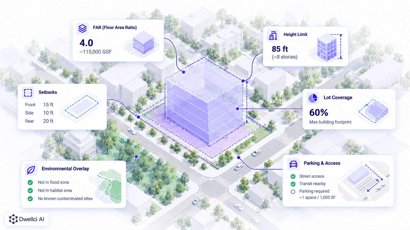
What you can build on a property depends on more than its zoning designation. Development potential is shaped by the intended use, density or FAR, setbacks, lot coverage, height limits, parcel geometry, parking and access requirements, overlays, and physical or environmental constraints. The real answer comes from applying those rules together to the specific site.
That is why the question “What can I build here?” is usually harder than it first appears.
A zoning map may identify the district. A property record may show the lot area. But neither tells you, by itself, what building can realistically fit on the site.
Terminology and rules vary by jurisdiction, but these seven categories provide a useful framework for screening development potential.
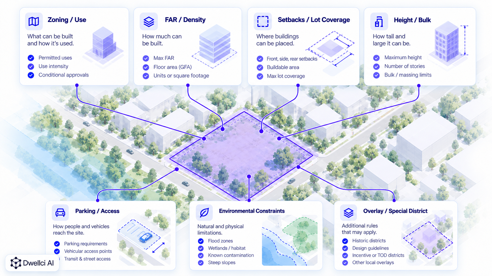
The first question is whether the intended use is allowed.
A zoning district may permit residential, commercial, industrial, mixed-use, institutional, or other categories of development. Some uses may be permitted by right, while others may require a special permit, conditional approval, variance, or other discretionary process.
That distinction matters because a site can have attractive dimensional capacity but still be unsuitable for the intended project if the use is not allowed or requires a difficult entitlement path.
Start with the development program, then verify whether the zoning framework supports it.
Density controls help determine how much development may be allowed.
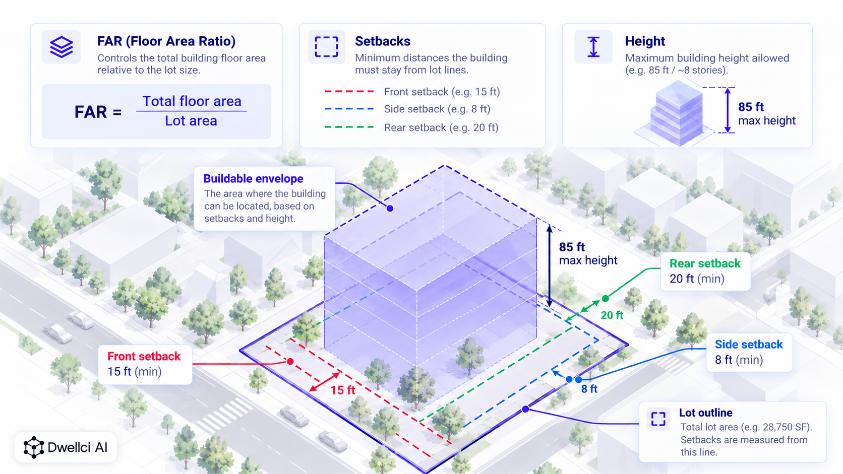
In many jurisdictions, one of the key metrics is Floor Area Ratio, or FAR. New York City's Zoning Resolution defines FAR as the total floor area on a zoning lot divided by the lot area. The New York City Zoning Resolution provides a clear formal example of the concept.
Consider a simplified property with 20,000 square feet of lot area and a permitted FAR of 2.5:
20,000 SF × 2.5 FAR = 50,000 SF of theoretical floor area
That is an important starting point.
But it is not the final answer.
Theoretical floor area still has to fit within the other dimensional and physical constraints that apply to the property.
Setbacks determine where on the parcel a building may be located. Lot-coverage rules can limit how much of the site the building footprint may occupy.
These controls can materially reduce the usable footprint even when the site has significant theoretical density.
For example, a narrow lot with large side-yard requirements may have a much smaller practical building width than its total lot area suggests.
Similarly, a lot-coverage limit can leave floor area unused unless the project can add additional stories within the permitted height.
This is one reason why development potential should be evaluated spatially rather than as a list of zoning values.
Height rules determine how far the project can develop vertically.
In some zoning systems, height and setback requirements work together to create a three-dimensional building envelope. New York City's 2025 Zoning Handbook explains that height and setback regulations shape the volume within which permitted floor area must fit. The NYC Zoning Handbook provides a useful visual explanation of this relationship.
The practical question is therefore not simply:
How much floor area is allowed?
It is:
Can that floor area physically fit inside the permitted envelope?
A site may have unused FAR because the combination of height, setbacks, footprint limits, and geometry prevents the theoretical maximum from being realized efficiently.
Development regulations often include requirements that compete for limited site area.
Parking spaces, drive aisles, loading areas, fire access, open space, landscaping, bicycle facilities, or other requirements can affect how much of the property remains available for the building itself.
This can be especially important on smaller infill sites, where a relatively modest requirement may have an outsized effect on building efficiency or unit yield.
Access also matters independently of zoning. A parcel with poor frontage, difficult ingress and egress, or uncertain legal access may be significantly harder to develop than a similarly zoned property nearby.
The base zoning district is not always the complete regulatory picture.
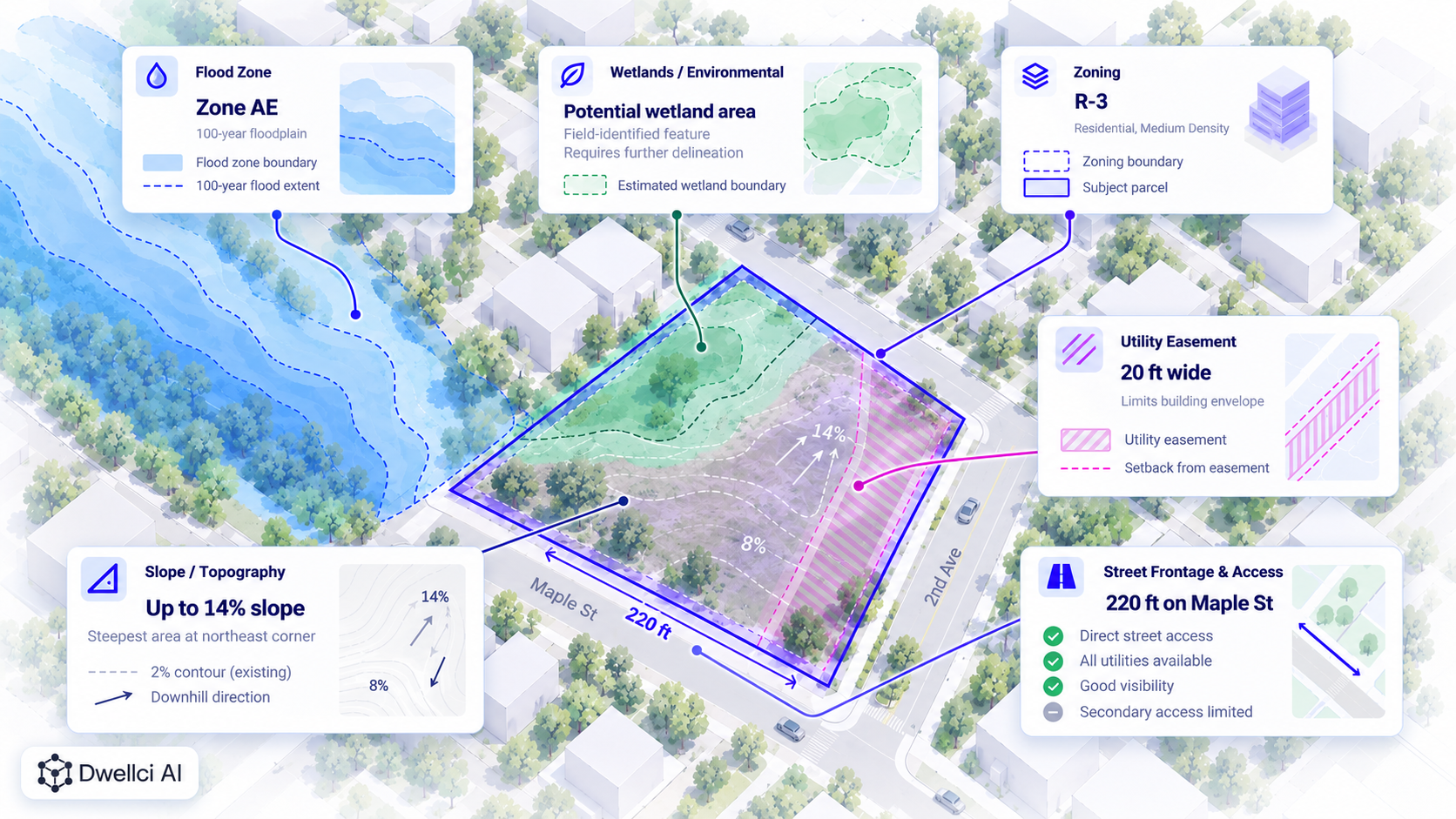
Properties may also be affected by overlays, special districts, historic controls, floodplain requirements, wetlands, environmental restrictions, steep slopes, easements, or other site-specific conditions.
FEMA's Flood Map Service Center provides official flood-hazard information used for the National Flood Insurance Program. FEMA's Flood Map Service Center is an important resource when flood conditions may affect a property.
Wetlands can also change development assumptions. Under Section 404 of the Clean Water Act, discharges of dredged or fill material into waters of the United States, including regulated wetlands, generally require authorization unless an exemption applies. EPA's Section 404 permit-program guidance provides additional context.
These conditions do not necessarily make a property undevelopable. They may change the buildable area, approval process, cost, or amount of professional investigation required.
Two parcels can have identical zoning and lot area but produce very different development outcomes.
Why?
Because development happens in three dimensions.
Lot width, depth, frontage, irregular boundaries, corner conditions, orientation, existing improvements, access points, and adjacent conditions can all affect how efficiently a project fits.
The development program matters too. A multifamily building, townhouse project, hotel, warehouse, or mixed-use building may use the same zoning envelope very differently.
This is why the final answer to “What can I build?” requires both regulatory analysis and a development scenario.
A zoning lookup is useful for identifying the rules associated with a property.
But the development question is more specific:
What do those rules produce when they are applied together on this exact parcel?
That requires moving from zoning information to site feasibility.
For example, a zoning lookup might tell you:
A feasibility analysis should go further and show how those controls interact to shape a plausible building envelope, floor area, coverage, height, and yield.
Imagine two 20,000-square-foot parcels that both allow 2.5 FAR.
On paper, both may suggest 50,000 square feet of theoretical floor area.
But Parcel A is rectangular, has generous frontage, and allows a straightforward building footprint.
Parcel B is narrow, irregular, and affected by a large setback and flood condition.
The same FAR does not produce the same development opportunity.
That is the difference between theoretical zoning capacity and practical buildable potential.
Before an acquisition decision, a developer should have enough information to understand the site's apparent opportunity and its largest unknowns.
That does not mean every issue must be solved.
It means the acquisition team should know which assumptions the deal depends on.
A strong early review should identify:
Buildable potential is one input into an acquisition decision, not the entire investment decision. Market demand, land basis, construction costs, financing, title, utility capacity, entitlement timing, and other diligence can still change whether a physically developable site makes sense.
For a more complete acquisition workflow, see How to Evaluate a Development Site Before Acquisition.
Dwellci AI is designed for the phase-zero stage of real estate development.
The platform combines parcel intelligence, zoning analysis, site constraints, and computational 3D feasibility so development teams can move from raw property information to a clearer picture of buildable potential.
Dwellci can help teams screen sites, compare opportunities, and generate zoning-backed 3D massing with development metrics such as FAR, height, site coverage, and unit yield before significant capital is committed or detailed design begins.
Dwellci supports development site analysis nationwide across all 50 U.S. states.
No. The zoning district is only the starting point. Permitted use, FAR or density, height, setbacks, lot coverage, parking, overlays, parcel geometry, and site constraints may all affect what can actually fit.
FAR controls the amount of floor area that may be permitted relative to lot area. Buildable potential depends on whether that floor area can fit within the site's height, setback, lot-coverage, geometry, and other constraints.
A buildable envelope is the three-dimensional space within which development may potentially occur after applicable dimensional controls are considered.
Yes. Flood conditions, wetlands, contamination concerns, topography, easements, and other physical or environmental constraints may affect usable site area, design, approvals, cost, or the need for deeper investigation.
Yes. Early feasibility is decision support, not a substitute for project-specific architectural, engineering, legal, environmental, survey, or other professional services.